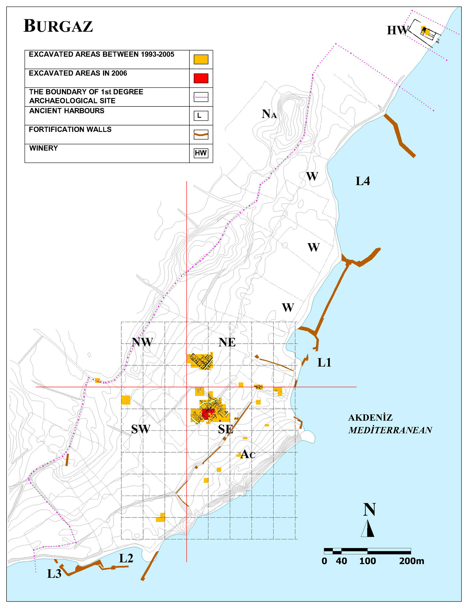
 Four harbors mark the site of Burgaz, marked on the plan as L1-L4 (liman, the Turkish word for harbor). A primary focus of the current project has been the exploration of L1 and its adjoining seawall. Now fairly small in size and limited in depth, L1 seems the best candidate for association with the earliest phases of the site. It is an excellent natural harbor, offering a good mooring space during the prevailing northwest meltem winds. Built extensions ensure some protection from the southerly lodos as well. Surface survey within the harbor has revealed cultural material from perhaps as early as the Archaic Period with a high proportion of amphoras, as would be expected from a harbor context. The visible walls that delimit L1 comprise a number of techniques ranging from cut masonry to large boulders and rubble fill. Along the north edge and extending toward the harbor mouth, a core wall seems to have been augmented and extended by piling large uncut stones. Last summer, we opened a test trench along this harbor wall. The majority of datable sherds from the lowest levels belong to the Late Classical and Early Hellenistic eras. Large rocks and notable quantities of roof tiles throughout the area may point to the collapse some structure, perhaps associated with a sea level change. We suspect that the harbor wall and the sea wall connecting L1 and L4 may be related to the fortification of the city during the Late Classical period.
The focus of commercial activity at Burgaz seems to shift after the fourth century to the north of the original settlement core, moving particularly toward the area surrounding the large harbor labeled L4, a less sheltered but certainly larger and less silted alternative to L1. Along the southern end of L4, workshop structures extend from onshore into the shallows. These include several built storage basins and a submerged fragmentary wine press. Survey and surface collection of diagnostic ceramics in and around the workshops suggest use during the Hellenistic era and perhaps again in Late Antiquity. A large Hellenistic winery and associated wharf excavated by the METU team just north of L4 confirms the general drift of industry away from the original settlement. In addition to architectural features, the scattered ceramic remains of a probable Late Roman shipwreck at approximately 4 m of depth just inside the northern mole of L4, confirm the harbor’s use beyond the Hellenistic period. Diagnostic features of various Late Roman 1 and Late Roman 2 amphoras can be seen on the seabed.
To the south of the town and its acropolis, harbor facilities continue in the areas designated as L2 and L3. Built harbor structures here include moles and two towers: one located at the end of the northern mole, the other near the center of the southern mole. Both towers are approximately square, with dimensions ranging from 7.5 m to nearly 9 m. Together, the moles protect the harbor in most seasonal weather conditions and the towers may suggest a military purpose. Thucydides (8.43) speaks of Knidos as a military base and repair station for warships during the Peloponnesian War. While new construction in L2 does not seem to continue long after the notional abandonment of the site, surely these fortified constructions could have served useful commercial and military functions in the fourth century and beyond.